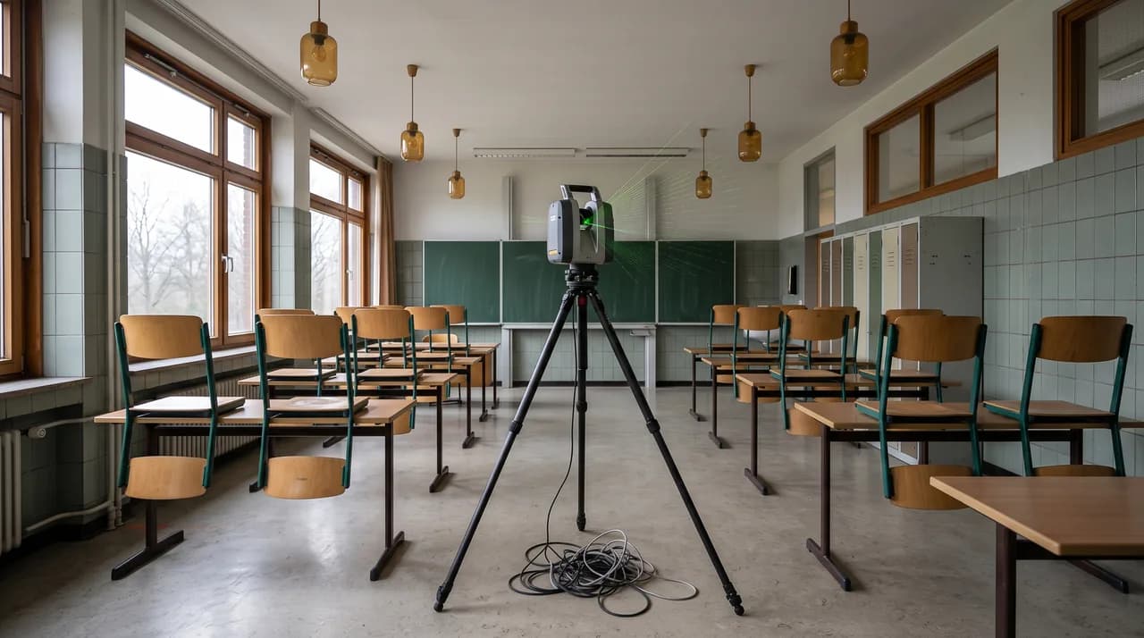
A school is rarely a single, tidy structure. It is a living organism of classrooms, corridors, stairwells, gymnasiums, cafeterias, technical rooms, and outdoor areas, occupied for most of the day by hundreds of children and staff. When a municipality plans a renovation, an energy retrofit, or a fire safety upgrade, everything begins with one deceptively simple question: what does the building actually look like today, in precise, measurable terms?
For school administrators and municipal facility managers, the answer used to arrive as a stack of outdated paper plans that no longer matched reality. Today it arrives as a millimetre-accurate 3D point cloud and a set of dimensionally correct floor plans. But surveying a school is not like surveying an empty office. It sits at the intersection of technical precision, tight scheduling, and child protection. This guide walks through how a professional survey of a school building is planned and executed, step by step.
Why a School Building Is a Special Surveying Project
Most commercial surveys can be booked, scheduled, and completed with little regard for who occupies the building. A school is the opposite. It is a highly regulated environment where the presence of minors, the rhythm of the timetable, and the involvement of a public authority all shape how the work must be carried out. A surveyor who treats a primary school like a vacant warehouse will cause disruption at best and a safeguarding incident at worst.
Three factors make schools distinctive. First, the building is almost never empty during term time, which forces the survey into holidays, weekends, or after-hours slots. Second, the people inside are children, so data protection and safeguarding obligations apply with unusual force. Third, the client is typically not a single decision-maker but a chain of stakeholders: the school leadership, the municipal facility department, and often a building or works committee that has to approve access and budget.
Understanding these constraints early is what separates a smooth project from a stalled one. A specialist provider plans backwards from them, treating the timetable and the safeguarding rules as fixed boundaries rather than obstacles to be negotiated on the day. The technical scanning is, in truth, the most predictable part of the whole exercise.
Scheduling Around Holidays and Off-Hours
The single most important planning decision is timing. Laser scanning requires clear lines of sight and undisturbed rooms; every person, open door, or moving chair introduces gaps and noise into the point cloud. In an occupied classroom that is impossible to control, so the survey is deliberately pushed into windows when the building is quiet or empty.
School holidays are the ideal window. During the summer break in particular, an entire building can be captured in a single continuous campaign, with unrestricted access to every room and no risk of interrupting lessons. Shorter breaks, such as autumn or spring holidays, suit smaller buildings or partial surveys. Where a full holiday campaign is not possible, the work is arranged in the late afternoon and evening after pupils have gone home, or across a weekend, sometimes floor by floor so that teaching continues undisturbed in the rest of the building.
For the facility manager this means booking well ahead. Holiday slots for surveying are limited and fill quickly, because renovation and retrofit programmes across a municipality tend to converge on the same few weeks. The practical rule is to confirm the survey date as soon as the project is approved, ideally one to two holiday periods in advance, and to build in a buffer for weather-independent interior work so that a delayed decision does not push the whole project into the following school year.
Safeguarding and Child Protection on Site
Wherever minors are present, child protection takes precedence over convenience. The guiding principle of a professional school survey is simple: no student should ever appear in the captured data. Because holiday and off-hours scheduling already removes pupils from the building, this is usually straightforward, but it must be treated as a hard requirement, not an afterthought.
When scanning cannot avoid occupied periods entirely, additional measures apply. Rooms are cleared before capture, corridors are scanned during class time when they are empty rather than at breaks, and any incidental imagery is reviewed and, if necessary, blurred or deleted before delivery. Reputable providers work to documented data protection standards, restrict who can access the raw files, and confirm in writing that the deliverables contain no identifiable individuals. Staff on site should be briefed too, since some may not wish to appear in panoramic imagery either.
Communication closes the loop. Before the survey, the school informs its teachers, caretakers, and administrative staff about what will happen, who will be on the premises, and what equipment they will see. Where the school considers it appropriate, parents are notified as well, so that the presence of technicians and tripods is understood in advance rather than questioned after the fact. Surveyors typically carry identification, sign in through the school office, and are accompanied by a caretaker or facility contact who holds the keys and knows the building. This transparency is not bureaucratic overhead; it is what allows the work to proceed without alarm.
The Complexity of a Typical School Building
Schools present a particular kind of technical challenge: they are large, repetitive, and full of near-identical spaces. A secondary school can contain dozens of classrooms that look almost the same, connected by long corridors and multiple stairwells. Without careful organisation, it becomes surprisingly easy to lose track of which scan belongs to which room, or to overlook a store cupboard behind an unmarked door.
Then there are the outliers. A gymnasium is a single high-volume space with a ceiling far above the reach of a standard tripod, often crossed by structural trusses, lighting rigs, and ventilation ducts that all need to be captured. A cafeteria or assembly hall combines large open areas with service kitchens and technical zones. Specialist rooms, science labs, workshops, music rooms, IT suites, add fixed installations, benches, and equipment that must be recorded accurately for any later refurbishment. Basements and roof spaces hide the heating plant, electrical distribution, and ventilation systems that dominate energy and fire safety planning.
To manage this, the surveyor works to a systematic room-by-room plan, usually derived from the existing floor plans and a walkthrough on the first day. Each space is labelled and logged as it is captured, so the final point cloud can be navigated logically rather than as an undifferentiated cloud of points. Overlapping scan positions tie the rooms together into one coherent model, and control measurements verify that a building spanning several wings and floors closes correctly on itself rather than drifting out of alignment.
How the Survey Is Actually Carried Out
The core method for a modern school survey is 3D laser scanning, often combined with mobile SLAM systems for speed. A terrestrial scanner is set up on a tripod in each room and captures millions of measurement points per second, recording the exact geometry of walls, floors, ceilings, windows, doors, and fixed installations. Where large corridor networks or repetitive floors need to be covered quickly, a handheld or backpack-mounted mobile scanner is walked through the building, capturing continuously at walking pace.
The result is a dense point cloud: a precise, three-dimensional digital replica of the building as it stands today. Colour imagery is usually captured alongside the geometry, producing a navigable model in which every dimension can be measured after the fact, without a second visit. If a planner later needs the exact width of a doorway or the height of a gym ceiling, the answer is already in the data. Exterior facades, roofs, and courtyards, the traditional blind spots, can be added with drone-based scanning where access from the ground is not enough.
On site, the fieldwork for an average school runs from one to several days depending on size and the number of scan positions. The heavier lift is the processing that follows: registering the individual scans into one coordinate system, cleaning stray points, and converting the raw cloud into the deliverables the client actually needs, whether that is to-scale 2D floor plans, sections and elevations, or a full BIM model ready for design software.
What the Survey Data Is Used For
A survey is only worthwhile if it feeds real decisions, and for a school the range of uses is unusually broad. The most immediate is space and capacity planning. Accurate floor plans and room areas let administrators understand exactly how much usable space exists, reorganise class allocations, plan extensions, or model the impact of changing pupil numbers without measuring anything by hand.
Renovation and refurbishment projects depend on the same data. Architects and engineers design against the building as it truly is, not against decades-old drawings, which removes the costly surprises that emerge when a wall turns out to be in a different place than the plan showed. Energy retrofits, a major driver of municipal building programmes, rely on precise geometry to calculate insulation, glazing, and heating requirements, and to document the improvements for funding applications. The captured plant rooms and ventilation routes directly support these calculations.
Fire safety and emergency documentation is a further, often decisive, use case. Up-to-date, dimensionally correct plans of escape routes, corridors, stairwells, and exits are a legal necessity for schools, and a current 3D survey provides an authoritative basis for them. The same model supports accessibility audits, asset and maintenance management, and, increasingly, a digital twin that the facility department keeps as the single source of truth for the building across its entire lifecycle. One survey campaign therefore serves many departments at once, which is a strong argument for capturing the building thoroughly the first time.
Coordinating with Administration and Facility Departments
A school survey has more stakeholders than most projects, and coordination is where schedules are won or lost. On one side sits the school itself, the head teacher, the school office, and the caretaker who controls physical access. On the other sits the municipal facility or property department, which usually commissions and pays for the work and owns the resulting data. A building committee or procurement office may also need to approve access and cost before anything happens.
Good coordination starts with a single, clearly identified point of contact on each side. The facility manager defines the scope and deliverables and secures the budget; the school arranges the practical details, such as which days the building is free, who will unlock which rooms, and how the surveyors sign in. The caretaker's knowledge is invaluable here, because they know which doors stick, where the plant rooms are, and which spaces are locked for good reason. A short kickoff walkthrough before the survey date resolves most of these questions in advance.
Clear agreements on data ownership and access round out the coordination. Because the deliverables belong to the municipality and may be shared with architects, engineers, and fire safety consultants, everyone should know from the outset who receives the files, in what formats, and under what confidentiality terms, especially given the child protection sensitivities. Getting this settled early prevents the common situation where a completed survey sits unused because no one is sure who is allowed to hand it on.
A Typical Project Timeline
While every building differs, a school survey follows a recognisable rhythm. It begins with an enquiry and scoping conversation, usually four to eight weeks before the intended survey window, in which the facility department describes the building, the intended use of the data, and the constraints. From this the provider prepares a proposal defining scope, deliverables, and the on-site schedule, and the survey date is locked into a holiday or off-hours slot.
In the run-up, roughly one to two weeks before, the practical arrangements are confirmed: access, keys, the site contact, the room-by-room plan, and the safeguarding measures. The school notifies its staff, and parents where appropriate. The fieldwork itself is the shortest phase, typically one to a few days on site for a single building, carried out while the school is empty. For larger campuses or multi-building sites, the campaign may run across a full holiday week.
Processing and delivery follow. Registering and cleaning the point cloud and producing the finished plans or BIM model usually takes one to three weeks, depending on the depth of deliverables ordered. Simple 2D floor plans are quicker; a fully modelled digital twin takes longer. Allowing for scheduling around holidays, the realistic span from first contact to delivered documentation is often six to ten weeks, which is why aligning the enquiry with the school calendar is the most valuable planning move a facility manager can make.
Conclusion
Surveying a school building is a technical task wrapped in an organisational one. The laser scanning that produces the point cloud is fast, precise, and well understood; the real craft lies in fitting that work into the life of an occupied school without disrupting lessons or compromising the safety of children. Scheduling around holidays and off-hours, keeping students out of frame, communicating with staff and parents, and coordinating a chain of stakeholders from the caretaker to the municipal property office are what make the difference between a clean project and a troubled one.
For school administrators and municipal facility managers, the payoff is a single, authoritative record of the building that serves space planning, renovation, energy retrofit, and fire safety documentation for years to come. FotoEstate approaches these projects with both the surveying technology and the safeguarding discipline that public buildings demand, delivering finished, to-scale plans and digital twins rather than raw data. Booked into the right holiday window and coordinated early, a school survey becomes the reliable foundation on which every later decision about the building can safely rest.