Hero Background
B2B real estate marketing

Drone video for commercial real estate

For commercial and logistics properties, the location determines the investment. Conventional land surveys fail to convey the big picture. With high-resolution drone videos, we present the macro location, transport connections, and the true dimensions of your property in cinematic premium quality.

Why a drone video is the ultimate pitch deck for your commercial property

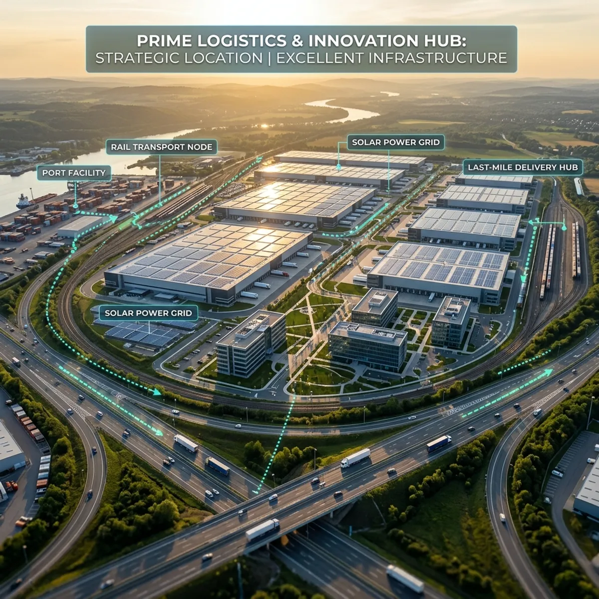
The sale of commercial real estate – be it huge logistics parks, modern office complexes, extensive retail spaces, or complex industrial facilities – works fundamentally differently than the sale of private residential properties. Your target group consists of institutional investors, strict asset managers, logistics executives, and analysts. These decision-makers do not buy a 'cozy living room atmosphere.' They buy hard facts: accessibility, infrastructure, scalability, delivery options, and strategic location advantages (macro and micro location). If you want to convey these enormous dimensions and logistical interrelationships with classic, ground-level photos, you immediately encounter visual limits. A 10,000-square-meter commercial hall looks from the ground perspective just looks like an endless sheet metal wall. Any context is missing. This is exactly where a professional drone video for commercial real estate unfolds its unbeatable persuasive power.Spectacular aerial view of a modern commercial and logistics park at sunset, with digital graphics for highway connectionsWith our state-of-the-art camera drones (UAVs), we rise above the limitations of ground perspective. We capture the property from flight heights of up to 100 meters and deliver brilliant 4K videos that reveal the entire potential of the property at a glance. The investor immediately sees the exact Arrangement of the truck loading ramps, the turning possibilities in the company yard, the parking capacities for employees, and the available expansion areas. But we go one crucial step further than just providing beautiful aerial footage: we enhance our drone videos in post-production with graphical 3D overlays (motion tracking). In the running video, we display the exact distances to the nearest highway entrance (A1, A7, etc.), to the nearest freight train station, or to the airport directly in the landscape. We visually mark property boundaries and highlight important neighboring companies (cluster formation). This concentrated, visually prepared layer of information makes your video the perfect, self-explanatory pitch deck. When an asset manager opens your exposé and When he watches this three-minute, cinematically edited drone film, he no longer needs lengthy site analyses – he has already understood the attractiveness of the investment both emotionally and intellectually. This enormously accelerates the due diligence process, separates qualified leads from mere prospects, and massively strengthens your negotiating position in enforcing premium purchase or rental prices.
B2B real estate marketing – visualization example

Your benefits at a glance

Proof of the strategic macro situation

Location is the most important factor for returns in commercial properties. With graphically prepared drone videos, you can demonstrate the proximity to transport hubs (highways, ports, airports) at a glance. Investors no longer need to study maps but can see the logistical advantages directly and impressively animated in the video.

Making true dimensions visible

Logistics halls, shopping centers, or production facilities cannot be visually captured from the ground. Only the bird's-eye view shows the true dimensions of the roof areas (interesting for photovoltaic investments), the complete loading zones for heavy-duty traffic, and the potential of unused reserve areas on the property.

Heavily shortened due diligence process

Transparency creates trust and speed. The more comprehensive and clear the visual material is in advance, the fewer lengthy on-site inspections by committees and appraisers are necessary. The drone video already answers 80% of site-specific questions in the initial contact and accelerates the transaction process.

Highly professional B2B marketing

Anyone offering multi-million investments must also present themselves accordingly. A shaky cellphone video is absolutely out of place here. A cinematically edited, color-corrected drone video in 4K resolution, accompanied by appropriate corporate music and your agency branding, positions you as an absolute top player in the market.

How it works

  1. Request

    You describe your property and goal – we confirm scope and price.

  2. Briefing

    We clarify style, material and deliverables with you.

  3. Production

    We create the visuals or capture on site.

  4. Delivery

    You receive the finished files ready for listing and marketing.

Everything you need to know about B2B real estate marketing

Frequently asked questions

Yes, flying drones over commercial and industrial areas is strictly regulated in Germany and Europe. As a professional media production company, all our pilots possess the EU remote pilot certificate (large drone license) as well as all legally required commercial liability insurances. We take care of all necessary flight permits from the local aviation authorities in advance, clarify restrictions in control zones (CTR) of airports, and coordinate the flight with the on-site security.

This is our specialty. Using so-called 3D motion tracking, we seamlessly link the real drone footage with digital information. We draw animated lines on the ground to mark the exact boundaries of the plot, display floating text boxes showing the distance to the highway or the square footage of individual hall sections, and can even integrate halls yet to be built (CGI) photorealistically into the video of the existing landscape.

Of course. The drone flight is always used comprehensively. In addition to the high-resolution 4K video material, we simultaneously photograph the property in the highest resolution (often in RAW format) from various strategically important angles and heights. These photos are professionally retouched, corrected for distortion, and can be perfectly used for large-format prints in your investment memoranda (IM) or print exposés.

Commercial properties must radiate competence and quality – bad weather (rain, dense fog) prevents this. That is why we work with a 100% good-weather guarantee. We continuously monitor the weather data at the location. If the weather on the scheduled production day does not provide the necessary quality (ideal are sunshine or a lightly cloudy sky for soft shadows), we will postpone the drone flight to the next optimal day at no additional cancellation cost to you.

Strategy Inquiry
FotoEstate

Ready for the perfect first impression?

Increase your sales prospects with professional property marketing.

Start your project